Topics
GeographyHeadlinesInfrastructureKatrinaNeighborhoodsPeopleRecreation
|
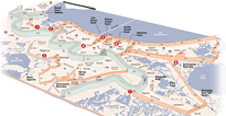 New Orleans Levee System
Levees were built along the river from the earliest days to
curb the spring flooding that plagued the city. Canals were dug for commerce
and drainage. For its first two hundred years the city was restricted to the
natural high ground along the river banks and the Metairie and Gentilly ridges. In 1913 local
engineer A.B.Wood invented the inline drainage pump. Fourteen foot
models capable of moving 60 thousand cubic feet of water per minute were
installed to speed the drainage process by lifting water from the
canals
into surrounding lakes. The back swamps were gradually developed into
subdivisions. As the land drained it settled. Levees were added to
protect
the new land not just from the river but from the surrounding lakes and
ultimately the Gulf itself. An unstable equilibrium developed between
the land
and its surrounding waterways.
The
levees and spillways built to control the river slowly changed the
equilibrium.
Levees were extended nearly to the mouth of the river on the west and
past St Bernard parish on the east. Jetties were built at the mouth of
the river to speed the flow and scour navigable channels to maintain a 40 foot deep channel. The Corps
constantly dredges any trouble spots.
Spillways were added to divert floods that could top the levees. As a
result there have
been no river floods, no silt and no new land deposited in southeast
Louisiana
for over a hundred years (excluding the contribution in 1927 to St.
Bernard
Parish when levees were intentionally dynamited). There is no bedrock,
just
hundreds of feet of compacted silt under the city, so the inevitable is
occurring. The city, its levees and the entire region is sinking.
|