Topics
GeographyHeadlinesInfrastructureKatrinaNeighborhoodsPeopleRecreation
|
Eye of storm 15 miles east of New Orleans. Sustained winds in the CBD
in the 80's gusts over 100. Higher in the east. Funnel effect plus
breaks in the MrGo, Arpent and Industrial canal levees assures flooding of the east
including St Bernard, Plaquemines, New Orleans east and the lower Ninth
Ward.
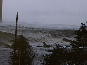
Pictured here you can see the storm surge topping the Intercoastal
Waterway levee at Michoud and pouring into New Orleans East. This is
part of the first flood driven up Mr GO and across Lake Borgne through
the "funnel" and into the city.
As the water tops the levee it scours away the land on the "dry" side creating a crevasse or total failure of the levee.
There are reports that as the winds began dying down at about 9:00 am
residents of Arabi, the community due south of the spot in the picture,
were beginning to step outside thinking the worst was over. A few
minutes later when the Industrial Canal levees failed along Tennessee
Street water poured across the railroad tracks from the Lower Ninth
Ward of Orleans into Arabi climbing to over ten feet in spots. this
report doesn't quite match the main chronology and needs confirmation.
|