Topics
GeographyHeadlinesInfrastructureKatrinaNeighborhoodsPeopleRecreation
|
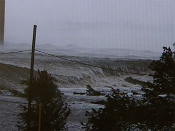
Flood number 3 occurred first in New Orleans East when the waters from Lake Borgne were driven east across the Bayou Sauvage wetlands and into this basin.
Water entered New Orleans East from the north along Lake Ponchartrain, the east from Lake Borgne, the south from the GIWW and the west from the Industrial Canal. It is pretty clear that the East was overwhelmed by this storm.
This area of the city was built on a
reclaimed swamp only
in the past fifty years. It is settling much faster than any other part
of the city. Initially it was the buffer the rest of the city enjoyed
against storm passage to the east but it was developed into housing as
the city ran out of land to the west.
Living in this buffer is a
problem.
Raised structures, high levees and restoration of the wetlands may
protect this area against anything less than a big category four storm.
Low density inexpensive slab-on-grade residential housing in the East is not a good option. Construction along the Gentilly Ridge (US90) is your best bet as this area experienced the least flooding.
|