Topics
GeographyHeadlinesInfrastructureKatrinaNeighborhoodsPeopleRecreation
|
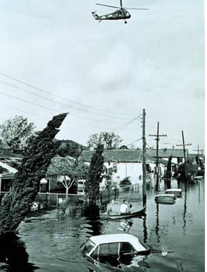 Lower 9th Ward after Hurricane Betsy in 1969
Hurricanes blast the city every few decades. Big ones hit somewhere on
the coast almost every year. With the exceptions of the 1893
Cheniere Caminada disaster (1,500 deaths) and the Galveston Hurricane
of 1900 (with 6,000 deaths) hurricanes in the US have not caused the
loss of
life that we saw in Katrina.
In the past fewer people lived here, they lived
on higher land, and they lived in rasied structures built on piers to defend against river, the lake and the
rain. Flooding in the East, Kenner, St. Bernard,
downriver in Plaquemines or along the lakefront happened from time to
time and was not a big disaster. The marshes surrounding the city were
in good shape and provided "horizontal levees" that protected the core
of the city for 200 years.
Before 1935 Louisiana was the only state in the nation actively
adding new land. The Mississippi and Atchafalaya deltas were building
new land in the marsh as they deposited their loads of silt and
freshwater. In 1935 the state stopped growing and started
shrinking. The levee system denied silt and freshwater to the
marshes so they began to die faster than they were replenished. Oil exploration was in full swing across
the marsh and hundreds of miles of canals were cut to provide access
for the work boats, drilling rigs and pipelines. The canals allowed
salt water into the interior of the marsh accelerating the damage.
At
first the changes were small and the nation's
attention was rivited to greater issues with World War II raging across Europe.
The
1947 Hurricane once again flooded the lakefront and much of East
Jefferson. The damage was slight, but the post WWII economic boom was
underway and people needed places to live. Drainage pumps in use since
1912 were drying the interior swamp of the central city
and it was rapidly developing but more land was needed. So it was time
to build and raise levees along the southern
Lake Pontchartrain shoreline from New Orleans East to Kenner and the city grew.
In
Orleans the levees are penetrated by the old
canals which terminate at ancient pumping stations. The pumps are still
in their
original locations several miles inland, along the
fringes of the old backswamp. You can't plug the canals at the
lakefront because then you couldn't pump the water out. It would make
more sense for the pumping stations to be at the lakefront, but that
wasn't where they were built in 1912 and it would cost $100's of
millions to move each one. So the levees along the canals became part
of the city's first line of defense. In Jefferson Parish
and New Orleans East the pumping stations were built on the lakefront
right from the start so interior levees were not needed.
In 1963 MRGO was opened. Environmentalists complained about the
potential for damage
to the wetlands but were not heard. Progress, the Michoud NASA plant,
the Vietnam War were all more important. Levees along MRGO isolated
47,000 acres of Cypress forest and swampland along the eastern sife of
St. Bernard Parish.
In 1965 Hurricane Betsy flooded the city again. There were
a few problems with the levees on the lakefront and along the
Industrial
Canal. The lower ninth ward flooded to the eaves and hundreds were
rescued from their roofs. President Lyndon Johnson visited and the
Corps of Engineers was tasked by Congress with providing a
comprehensive Hurricane Protection System for the city. Progress was
slow and funding spotty.
Initially conceived as a decade long project starting in 1965, it would
be
only partially complete when Katrina arrived in 2005.
In
2005 Katrina inundated Plaquemines, St. Bernard, 80% of Orleans,
parts of Jefferson and St. Tammany parishes. Some of the water receded
rapidly, but it took 42 days to empty the central basin. Congress acted
quickly to bayonet the wounded but failed to do anything substantial to
deal with the problem. They allocated money to FEMA, USACE and CDBG
grants that the city needed to survive and recover. The USACE money
included funds for restoration of the levees but not the wetlands. Oil
money that could have helped the wetlands remained mired in politics and only at tiny fraction released.
By
late 2006 it appeared the sense of urgency at the Corps was fading. Even
though the marsh is still shrinking, nothing is being done about that
problem. The levees were restored to preK status (which as you might recall, is not very good), but they were not improved
with armoring and some are already showing signs of deterioration.
Temporary floodgates at the mouths of the outfall canals are equipped
with inadequate temporary pumps plagued by vibration problems. MrGO is
no longer being dredged but it is still open and still being debated.
Then there was change at the USACE. Strock was out Van Antwerp was in. MRGO was closed and the real engineering began. Later Bush was out and Obama took the top job. No matter what you may have heard about the financial crisis, or on Rush Radio, Obama has been effective for New Orleans. Since 2006 New Orleans has been the nation's number one engineering project. This nation can do good work when it puts it's mind to it.
By 2011 New Orleans will be protected by the best engineering that the opening era of the 21st century can provide. 100 year protection in New Orleans is equivalent to 10,000 year protection in the Netherlands. There is still a problem in the wetlands but we may have purchased the years we need to solve that problem. The risk is that we will lose focus, but for now we are moving in the right direction. The next major update will come in 2014 when the temporary installations at the mouths of the outlet canals are due to be replaced.
|