The geology of the Mississippi River's Upper Basin
and the Lower Basin are quite distinct. The Upper Basin is
characterized by highlands, plains, and geologically diverse
mountainous regions. Firmly rooted in bedrock, the highlands are
gradually being eroded and the soil carried away by the river. The
lower basin fills a geological crease created during the formation of the
continent. Originally an inland sea it has been filled by deposition of
the soils carried south from the highlands.
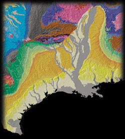
Geologists call the crease the "Mississippi Embayment." It stretches from Illinois to the Gulf and includes the
region from from East Texas to
Florida. Since the time of the
dinosaurs, over hundreds of millions of years, the
sea has done battle with the Mississippi River for control of the
entire area. The gray on the map represents silt deposited by
the Mississippi and other rivers in the embayment over the past 10,000
years. The light yellow includes deposits made up to 2 million years
ago. For the past 10,000 years, since the end of the last Ice Age, the battle with the sea has taken place in Louisiana.
New Orleans and much of the region around
Lake Pontchartrain are solidly in the gray. The land is less than
10,000 years old and solid ground is 70-100 feet below the surface.
As the silt compacts the whole area is slowly sinking and must be
constantly replenished by the river.
Why would anybody choose to
build a city in such an inhospitable place?