Topics
GeographyHeadlinesInfrastructureKatrinaNeighborhoodsPeopleRecreation
|
 click for national hurricane center
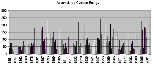
The_National Hurricane Center was not surprised by the number and
ferocity of the storms in 2005. They were however suprised by the lack of storms in 2006.
Their annual forecast called for more
storms than average. NOAA
watches something called the Accumulated Cyclone Energy index very
closely as a measure of the amount of
hurricane activity in any given year.
Recently forecasters recognized a 25 year trend in oceanic and
atmospheric
activity. (low activity
1970-1994, high activity 1995-2020?). In the historical ACE Chart above
if you look closely you may see what seems to be a repeating cycle. It's
irregular and even during a low period there can be a considerable
spike in any given year.
ACE is historical data combining
the numbers of systems, how long they existed and how intense they
became. It is calculated by summing the squares of the maximum sustained surface
wind speeds in storms of over 35 kts every six hours.
It is expressed in kt 2 divided by 10,000 to yield a reasonable size number What is the world is a kt 2 ? A square knot? Chuckle. It's because kinetic energy is defined as e = mv2 and that is what we are looking for i.e. the ability of a storm to do work (damage).
For years
forecasters looking for a cause have been observing the effects of ocean currents on the climate.
El Nino in the Pacific was one of the first to be related to wet and
dry cycles across the US. The wet cycles that corresponded to the presence
of El Nino also corresponded to a decrease in severe hurricane
formation. As more ocean currents
are being studied, modelers feel like they are closing in on "cause and effect." The Loop
Current is receiving significant attention because of its impact on storm intensity. But there are a number of worldwide weather patterns that have been correlated with tropical cyclones, hurricanes and major hurricane activity.
Click below to read more about the ocean current that directly affects the water temperature in the Gulf of Mexico and other worldwide weather phenomena:
2005 ACE - 248
2006 ACE - 76 (as of October 5)
|