Topics
GeographyHeadlinesInfrastructureKatrinaNeighborhoodsPeopleRecreation
|
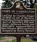
Carrollton began to be populated in 1835 and was incorporated in 1845 as a town in Jefferson Parish. For a time Carrollton was the Jefferson Parish seat of government with its own courthouse, jail, and offices. After Carrollton was annexed by New
Orleans in 1874 the courthouse was converted to school. The site housed McDonogh No. 23 Grammar School until 1957 when it became Benjamin Franklin Senior High
School after Franklin moved to the UNO campus, the courthouse became Lusher Middle School Extension.
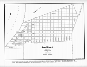
The boundaries of the city of Carrollton
are the Mississippi River, Jefferson Parish,
Claiborne Avenue, and Lowerline Street. This means parts of the current Leonidas neighborhood (aka West Carrollton) plus all of East Carrollton and Black Pearl made up the Old City of Carrollton.
Predominately a residential area, there are just a few commercial streets. Small restaurants, bars and shops can be found sprinkled around the area but are not concentrated in strip malls. The Camellia Grill draws a steady stream of tourists and locals
hungry for a Burger and a Freeze. The raw Cannibal Burger was discontinued due to health concerns in the eighties. Maple Street offers entertainment and
eats, catering to the college crowd from Tulane, Loyola and Newcombe. The
older and run down commercial district along Oak Street is gradually
being reborn with trendy upscale shops, restaurants, clubs and salons.
Carrollton
has long been ethnically mixed. Black and white families have lived
next to each other, on adjacent streets and in scattered groupings for
one hundred fifty years. Many
immigrants from Germany, Ireland, and the United States
settled here in the 19th century alongside many free persons of color. The neighborhoods are mostly one and two family homes ranging from
massive three story Victorian mansions to modest two family shotgun
doubles.
Residential construction started in 1835 and was largely complete before WW I. Flooding has always been a concern, and this concern is reflected in responsible designs. The Sauve Crevasse Flood of 1849 had a significant impact on this community and promoted responsible designs from the start. Most homes are raised
two or more feet above the already high ground. Only a very few
slab on ground homes and buildings constructed after 1950 can be found in Carrollton. Some multi-family apartment buildings can be found in the area and these tend to be student oriented small apartments in converted three story buildings.
Audubon
Park and Tulane University border Carrollton to the east providing recreation and commerce. Claiborne Avenue at the end of the street car line bounds
the neighborhood to the north. Before effective drainage pumps were deployed after 1913, the Caliborne Avenue boundary was also the edge of the back swamp and generally impassable.
Katrina's flooding crossed Claiborne Avenue leaving Palmer Park and the
bank at the corner of Claiborne and Carrollton in about three feet of
water. Flooding reached to within fifteen blocks of the river levee.
|
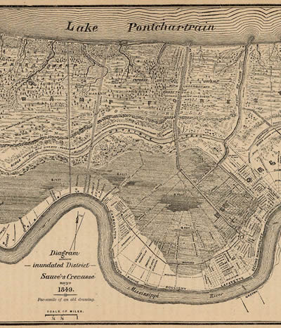
1849 Flood
: Sauvé's Crevasse was the last Mississippi River levee failure to flood much of New Orleans. It started May 3, 1849 when the spring floods broke through the levee at Pierre Sauvé's plantation in what is now River Ridge. Flooding filled the back swamp and threatened the rest of ths city until the First Municipality raised a small levee along the Carondelet Canal and shunted the waters out of town through Bayou St. John. Although the city east of Canal Street was saved, much of Carrollton (to Oak Street), Uptown (to Magazine) and the CBD (to Baronne) were badly flooded.
:: Continue reading...
|
|
|
2007 Tornado
: February 13, 2007 An F2 tornado touched down in Westwego just before 3am. Continuing toward the Northeast it crossed the river and clipped Carrollton. A few minutes later it touched down in Pontchartrain Park near Lakefront Airport before disappearing over the lake.
:: Continue reading...
|
|
|
Black Pearl
: The only part of Carrollton included in the highly gerrymandered 2nd Congressional District, this is the historically predominantly African-American part of Carrollton
:: Continue reading...
|
|
Carrollton - 1845
: As the streetcars began to upriver along St. Charles Avenue (then called Nyades) from the CBD developers eyed the high ground and began to lay out neighborhoods between the river and the back swamps. Charles Zimple was one of these men. He picked part of the Bienville Plantation for the site of Carrollton (why Carrollton? who was Carroll?)
:: Continue reading...
|
|
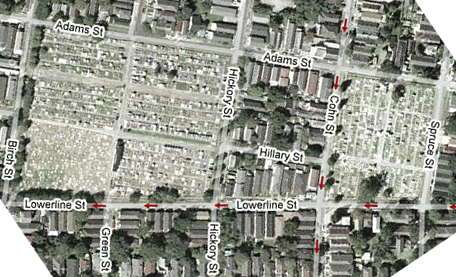
Carrollton Cemetery
: Two old cemeteries on Lowerline St. at the edge of Old Carrollton demonstrate just how self contained this community was.
:: Continue reading...
|
|
|
Driving in Carrollton
: Wow, these streets are narrow. With a Hummer H3 parked on the left and a Suburban on the right I can barely ride my Schwinn down the center. Residents learn to lay their rear view mirror on the street side flat when they park their cars. Oak Street is especially fun with two lanes of traffic going in opposite directions and parked cars on both sides of the street.
:: Continue reading...
|
|
|
Marlyville/ Fontainebleau Neighborhood
: Just north of Claiborne Avenue this area is technically outside of Old Carrollton but still considered by some to be a part of Carrollton because of similar architecture and population.
:: Continue reading...
|
|
|
Oak Street
: Oak Street runs 16 blocks from Tulane University, across Carrollton Avenue and then turns into the River Road Jefferson Parish line just across the railroad tracks near the levee.
:: Continue reading...
|
|
|
Riverbend
: Named not so much for the nearby sharp bend in the river, this area is named for the ninety degree turn in the St. Charles street car tracks where the line switches from St. Charles Avenue to Carrollton Avenue. Riverbend is eighty blocks from Canal Street and the French Quarter.
:: Continue reading...
|
|
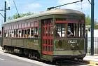
St. Charles Street Car
: Between New Orleans and the City of Carrollton runs the St. Charles
:: Continue reading...
|
|
|
The Batture
: Between the levee and the river there is a strip of land called the batture. Squatters lived on the batture until the Corps and levee police drove them away after World War II. Of course during the springtime with the river in flood stage the batture was swept clean.
:: Continue reading...
|
|
|
University District
: Also called Audubon, this area is dominated by Tulane and Loyola Universities and by Audubon Park. Beautiful tree lined streets and expensive homes surround the campuses and the park. This area is 86% white and had an average household income of $108,000 (more than double the city's average) in 2000.
:: Continue reading...
|
|
|
Uptown
:
:: Continue reading...
|
|